Graduate Work
This includes examples of graduate work done while at Saint Mary’s University of Minnesota. Feel free to send any comments or questions regarding my graduate project to sara@stolaf.edu.
Master of Science: Geographic Information Science – Graduate Project
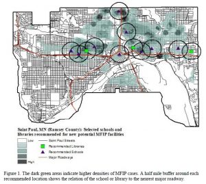
This research examines processes of locating new Minnesota Family Investment Program
facilities in Saint Paul, Minnesota. The goal was to site facilities where the greatest need
exists based on an analysis of demographic and geographic characteristics. Locations of the facilities were determined by identifying areas with the closest proximity to areas of high demand and near major roadways. Demographic variables examined included: a) ethnicities with the highest total recorded cases in the Minnesota Family Investment Program (MFIP), b) ethnicities with the highest number of total cases in the MFIP program for 59 months or more, c) and ethnicities with the highest number of children in the MFIP program. Potential locations for new facilities were determined by applying the following constraints. Each facility must be location in an area: a) within an area of high concentration of demand, b) within a location of a current school or library, c) within ½ mile of a major roadway. Point density maps were produced through use of Geographic Information Systems (GIS) to show findings.
An online link for this project is also posted Geographic Information Science Department of Resource Analysis grad papers page of the Saint Mary’s University of Minnesota website.
Program: Master of Science in Geographic Information Science
Resource Analysis – General MGIS coursework
RA554) GIS Analysis
This course uses different exams and assignments to explore ArcGIS software. A wide range of projects showcase the ways to use the program, and the methods of utilizing data in order to produce a desired result.
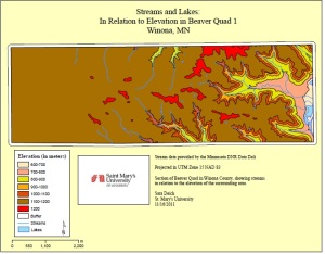
Beaver Quadrant 1 and Stream and Lakes: In Relation to Elevation in Beaver Quad 1
After replicating a previous quad map, this project instructed a user in digitizing these hand-drawn maps into ArcGIS in order to create a digital version.

Butterfly Project
Using the the tools of ArcGIS to digitize an image into the program, and then design the image to the user’s specifications. The purpose of this project was to improve skills and knowledge of creating, digitizing, and edition features in ArcGIS.

(RA556) Spatial Data Methodology
This class explores the different methods in collecting and analyzing data in ArcGIS. Throughout this course, multiple types of devices were used to capture data (total station, transit, GPS units), and this data was displayed in multiple ways.
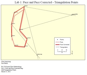
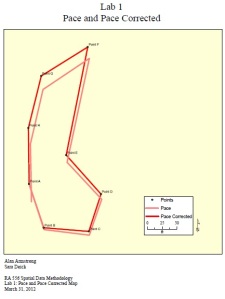
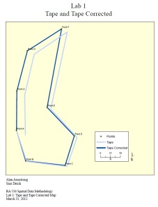
Pace and Tape Projects
Points were recorded in a study area and mapped to show the different ways the data may appear when collected in multiple ways.
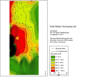
Total Station Surveying Lab
Using the total station, points and elevation were recorded in order to generate an elevation of the study area.
(RA642) Database/SQL
Exploring the relationship between data and tables, and how to link tables together. This course looks into the construction of databases, and the importance of how data is structured.
(RA563) Advanced Modeling and Analysis
This class studied different techniques and tool of ArcGIS, and how to apply these tools to real-life situations.
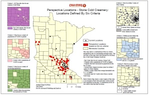
Coldstone: Perspective Locations
Variables from Census data were gathered in order to location new locations for a Coldstone restaurant. This was determined by combining different demographic variable to narrow down on a corresponding location for the new buildings.
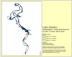
Lake Zumbro
This map shows a representation of data prediciting the potential reduction of Lake Zumbro over the course of 10, 20, and 30 years.
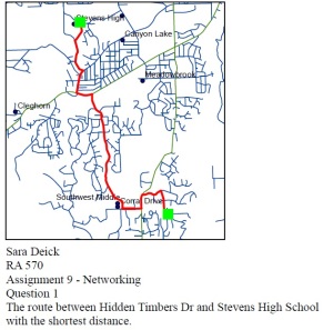
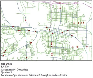
(RA570) Advanced GIS
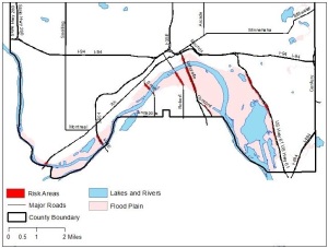
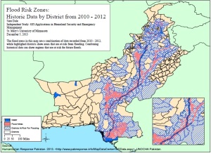
Risk Areas for Flooding
The Advanced GIS coursework employs Geographic Information Systems as a method to assess real-life situations. As an early introduction to risk management, related to the emphasis of homeland security, this project combines past data and potential flood areas to show areas of flood risk.
This course used a wide variety of tools in the ArcGIS program. I utilized geocoding networking, and created maps showing multiple data sets.
Homeland Security Coursework
(RA653) Natural Resource Risk Assessment and Management
This class incorporated an introduction to the Hazus software with a study of risk management and geohazards. Hazus allows a researcher access to a vast database of historical data about past floods, earthquakes, and hurricanes. Using this data, a user can conduct research on past natural disasters, or assemble a risk assessment of a study area.
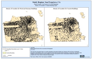
Study Region: San Francisco, CA
The map on the left shows casualties by building type in San Francisco, CA during the 1906 Earthquake.
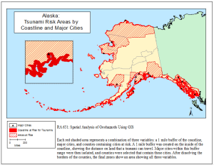
(RA651) Spatial Analysis of Geohazards Using GIS
This course studied different geohazards, such as earthquakes, and the geographic impacts of these hazards. The map of Alaska shows the risk areas for tsunamis.
Alaska: Tsunami Risk Areas by Coastline and Major Cities
This map outlines the areas of Alaskan coastline that are subject to potential Tsunami threat. Counties are also isolated as areas that contain cities that are near the coastline.
Independent Study: GIS Applications in Homeland Security and Emergency Management
This course explored different techniques and terms of Homeland Security, and the history behind the terminology and the United States Department of Homeland Security.
Flood Risk Zones: Historic Data by District from 2010-2012
This map shows regions of Pakistan that are at risk for flooding, combined with past recorded data of previous floods.
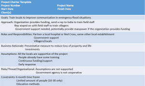
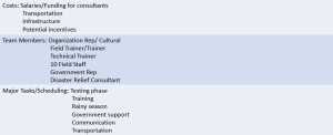
(PRM600) Fundamentals of Project Management
This course studied different techniques and fundamentals of project management, and exploring ways to apply this knowledge to real-life situations.
Constructing a project charter was the final project of this course. This hypothetical charter was meant to establish an organization that fulfills a need in a foreign country.